Participants: Bob Houze, Stacy Brodzik, Jim Moore, Dick Dirks
Wet MAP requires an operations center (called the Project Operations Center, or POC) in northern Italy. It will be located at the Aeroporto Militare, Linate, on the outskirts of Milano. This center will be responsible for guiding and coordinating the Wet MAP research flights of the WP-3D, Electra, French ARAT, French Fokker, and DLR Falcon aircraft in solo or coordinated flight operations. It may also help guide Dry MAP flights south of the Alps. To accomplish this real time requirement, a complex data flow must occur in which volumetric radar data from the Monte Lema, RONSARD, and S-Pol radars must be transmitted in real time to the POC. Data from 3-4 Italian operational weather radars must also flow into the POC. At the POC these radar data will be ingested into the University of Washington MountainZebra software (a modified Zebra platform designed for complex terrain). At the same time, positions of research aircraft flying in support of MAP must be provided to the POC from air traffic control. This position data will be ingested into MountainZebra, which will provide a continually updated composite display of all the ground-based radar data plus satellite and synoptic data. The ground-based mission scientist at the POC will use this display to coordinate the Wet MAP aircraft flights via voice communication, which must be available on demand for both the ground-based and airborne mission scientists. In addition, the POC and the MAP Operations Center (MOC) must be in close communication. The MOC will decide when and what type of aircraft missions will be launched. Once the aircraft are south of the Alps, responsibility for coordination of the mission will pass to the POC. To achieve this operational goal, there must be excellent communication between the POC and MOC for exchange of data and conferencing. The purpose of the visits to Zürich, Locarno, and Milano was to begin the process of setting up these vital real-time communication links.
Houze, Brodzik, and Moore met at ETH Hoenggerberg with Professor Hans Richner (Director of the MAP Data Center, MDC), Dr. Hans Hirter (Manager of the MDC), Dr. Peter Binder (Swiss Meteorological Agency, Director, MAP Program Office), and Dr. Andrea Rossa (Manager, MAP Program Office). We sought the advice of these key Swiss colleagues on how best to work with air traffic control in Italy, the problem of communication of large volumes of radar data by ISDN lines and other means in Italy and Switzerland, and how to obtain access to Italian operational radar data. In these matters we were advised to work through T.Col. Giuseppe Frustaci (Regional Meteorological Center, Milano Linate) and Dr. Marco Monai (Veneto Regional Weather Office).
Hirter gave us a detailed briefing on MDC's plans for real-time collection and distribution of satellite, synoptic, and model data during MAP operations. The basic plan is for these data to be collected centrally at the MDC in Zürich. There they will be placed on line and immediately available at the MDC, MOC, and POC. Thus, all MAP scientists in the field will always be looking at the same information. We also had preliminary discussions concerning what should be permanently archived at the MDC.
Moore suggested that this system be further enhanced with the JOSS data catalog, a web-based system by which each of the three centers may post products, which will immediately be available for viewing at the other two sites. This method will allow for radar products created at the POC to be available at the MOC. Similarly, flight plans and other information generated by Wet MAP PIs at the MOC will be immediately viewable at the POC. Products generated for inclusion on the JOSS catalog can be in gif or JPEG format.
Houze, Brodzik, and Moore met at the Ticino Observatory of the Swiss Meteorological Agency with Dr. Juerg Joss (Director of the Observatory), Dr. Gianmario Galli, and Dr. Urs. Germann. The Ticino Observatory operates the Monte Lema operational weather radar, which will be used in combination with the U. S. S-Pol and French RONSARD radars as the ground-based multiple Doppler network in the center of the Wet MAP observational array. At this meeting we discussed issues related to how the Monte Lema radar data can best be used in connection with the other radars as well as with the MAP aircraft. The following specific topics were discussed.
ACTION ITEM-Brodzik will coordinate with Galli to obtain sample "TODAY", "RAIN", and "WIND" products so that any format questions can be answered prior to the SOP.
ACTION ITEM-Brodzik will test the ftp transfer method and will modify existing code to make data ingest into MountainZebra automatically upon receipt of the data file.
ACTION ITEM-Brodzik will modify existing ingest code to handle the modified POLARZ product.
ACTION ITEM-The University of Washington will test this procedure.
ACTION ITEM-The University of Washington group and Ticino Observatory staff (especially Gianmario Galli) have agreed to work together to compile such a climatology by ingesting existing Monte Lema radar data sets into MountainZebra to produce three-dimensional echo composites, similar to those being worked on by James and Houze for the Eureka, California radar.
ACTION ITEM-It was agreed that Brodzik would go to Locarno in the spring of 1999 to conduct tests of the data transmission of all the products listed above and their ingestion into MountainZebra.
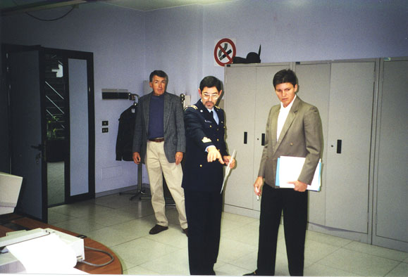
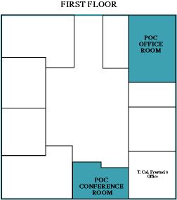
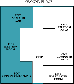
Houze, Brodzik, Moore, and Dirks met with T.Col. Giuseppe Frustaci and his staff at the Regional Meteorological Center (CMR), a military installation located at the Military Air Base, Linate, in the southeastern outskirts of Milano. The POC will be located in the CMR building on the air base. CMR will provide limited computer and communication assistance, limited daily forecasting support in coordination with the MOC, nowcasting support during Wet MAP missions, and liaison with the Milano air traffic control. T.Col. Frustaci will be the POC Director.
T.Col. Frustaci and his staff briefed us on the role of
the CMR in general and MAP in particular. The CMR is a fully
operational meteorological center serving northern Italy. We were
given a tour of the facilities, which have generously been offered to
MAP by the CMR. According to their offer, the POC will occupy rooms on
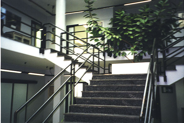
both the ground floor and the first floor of the CMR building. On the
ground floor, a stairway rises from the lobby
to the first floor. The meeting room to be
used for the daily science briefings during the SOP and the room set
aside for the Wet MAP operations center is
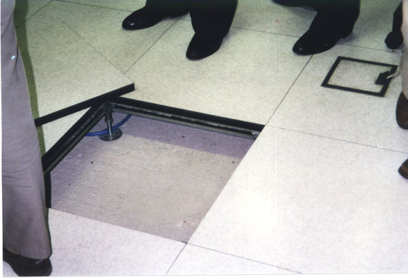
shown. The floor in this room is raised so
that there is accessible space underneath for laying computer cables
and other wiring that will be needed in POC operations. A similar
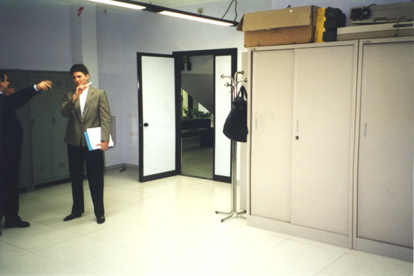
room will be set aside as an analysis lab
for the PIs working in the operations center. This room will have
space for workstations brought to the field by the PIs. On the first
floor, there will be a room for POC offices (Wet MAP Operations
Coordinator, Wet MAP Science Coordinator, etc.) and a small conference room.
T. Col. Frustaci reviewed the extent of forecasting support to be provided by the CMR and other Italian meteorological offices. A CMR shift forecaster will collaborate daily with the MOC during the preparation of the daily forecasts. The CMR will have a shift forecaster who will interact with the POC by providing daily weather forecasts in collaboration with the MOC. During IOPs, an additional Italian forecaster will aid the POC's ground-based mission scientist by providing timely nowcast input helpful to coordinating aircraft flights and deploying other facilities in an optimal mode. Detailed schedules and plans for these activities are being worked on by T.Col. Frustaci.
The computer infrastructure at the CMR appears to be generally compatible with the needs of the POC. They use a DEC Alpha 100 server and run both UNIX and Windows NT. CMR will provide computer support staff assistance in the set-up of the POC local area network (LAN) and provide limited assistance during the field phase. The building is well designed for laying cables to connect CMR machines with POC machines and to connect the POC machines with each other. The CMR computer network is protected by a firewall. The POC network will exist outside this firewall but have direct access to the Internet and datasets residing on CMR machines.
The CMR receives satellite images, synoptic maps, and numerical model fields on an operational basis. Certain of these products can be transferred to the POC machines. Brodzik was given the format of the sounding data.
ACTION ITEM-The CMR will provide Moore and Brodzik with information on these data formats in order for them to be displayed on POC machines. The satellite data formats are essential so that the satellite data can be ingested into MountainZebra.
ACTION ITEM-Moore and Brodzik will work with NCAR engineers to determine whether the format of the Italian satellite data can be ingested and registered in MountainZebra. This is also true of other data that might be available in the POC from the CMR.
ACTION ITEM-It was agreed that Brodzik would visit CMR in spring 1999. She will bring a workstation running MountainZebra and connect it to the CMR network to receive operational products. Tests will be run to generate the real-time, three-dimensional radar/satellite composite to be available at the POC on MountainZebra during the SOP. This product will serve as the basis for monitoring the precipitation over the Wet MAP domain and subsequent planning and guidance for Wet MAP aircraft flights.
The U.S. delegation raised the question of how the MOC and POC would coordinate their activities on a daily basis. It was agreed that some form of voice or video conferencing would be essential to keep the MOC and POC functioning in a complementary fashion.
ACTION ITEM-Both T.Col. Frustaci and the U.S. delegation will be looking for a solution to this communication need. A possible option would include working with the existing MDC ISDN network using cell and landline telephones and use of the "back-up" ISDN line between MOC and POC. It is important that the speed of communication should not be compromised, as instantly available conferencing between MOC and POC will be essential for the two centers to work in tandem.
ACTION ITEM-An estimate of telephone costs for this conferencing support will be made by the MOC and POC hosts and a decision must be reached about who pays for the telephone costs; this is a crucial and sensitive issue in the international MAP community.
Meetings on Oct 21 focused on the air traffic situation in Northern Italy as it might impact MAP operations and the receipt of Northern Italian operational radar data in real-time at the POC during the field phase. T.Col. Frustaci arranged for Mr. Pietro Paglia and Mr. Mauro Maran of the Milano civilian air traffic control center and Dr. Heinz Finkenzeller of DLR, Germany, to join the discussion about air traffic.
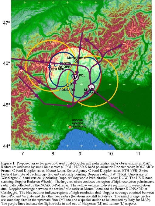 The civilian air controllers showed us the patterns
of approach and departure from Linate and Malpensa airports. A rough
sketch of these are shown superimposed on the Wet MAP radar network in
Fig. 1 on the right (click for caption). The dual-Doppler lobe to the
northwest is relatively free of air traffic at lower levels, as
departing aircraft on the outbound track across the lobe will be
generally higher than the WP-3D and Electra research flight
tracks. There are altitude limits for positive radar control (we have
been provided maps with this information) and minimum obstruction
clearance altitudes. Restricted military zones do not seem to present
a difficulty. MAP should be able to request access into those areas
during the SOP. In general, during daylight hours, it will be easier
to accomplish MAP aircraft operations in the dual-Doppler lobe to the
northwest than in the dual-Doppler lobe to the southeast.
The civilian air controllers showed us the patterns
of approach and departure from Linate and Malpensa airports. A rough
sketch of these are shown superimposed on the Wet MAP radar network in
Fig. 1 on the right (click for caption). The dual-Doppler lobe to the
northwest is relatively free of air traffic at lower levels, as
departing aircraft on the outbound track across the lobe will be
generally higher than the WP-3D and Electra research flight
tracks. There are altitude limits for positive radar control (we have
been provided maps with this information) and minimum obstruction
clearance altitudes. Restricted military zones do not seem to present
a difficulty. MAP should be able to request access into those areas
during the SOP. In general, during daylight hours, it will be easier
to accomplish MAP aircraft operations in the dual-Doppler lobe to the
northwest than in the dual-Doppler lobe to the southeast.
ACTION ITEM-Air traffic in the Milano region is 90% reduced at night (9 pm till 7 am) in the Milano area. Therefore there will be much more freedom for nighttime operations, at least from an air-traffic perspective. However, many airports are closed overnight. The MAP Scientific Steering Committee (SSC) and the Coordination and Implementation Group (CIG) must determine the trade-offs of night-time operations to achieve science objectives.
ACTION ITEM-The aircraft operations issue of identifying alternate landing sites for bad weather and night operations must be addressed. In Ascona, Finkenzeller said he would look into this.
ACTION ITEM-The access to a "dedicated" MAP radio frequency is under investigation by the MAP CIG and affected country officials. The initial frequency requested was turned down by certain countries. Another frequency has been chosen and approvals are being requested at this time. Such a frequency is very important for coordination of Wet MAP flights.
ACTION ITEM-The MAP scientists at the POC need the real-time position of MAP aircraft in order to overlay them on precipitation radar echo patterns and from these overlays advise the aircraft on what maneuvers would optimize their collection of data via airborne instrumentation. It is technically difficult to obtain the numerical data on the aircraft position from the air traffic control (ATC) computers and transfer them to a POC workstation. Technical personnel from the Italian ATC and Italian Air Force are investigating the feasibility of such a data transfer. If it is not possible to obtain the positions by direct computer data transfer, some less elegant method will be devised. One possibility is to make a video of the console dedicated to MAP at the ATC. Another possibility is to manually enter the position read from the ATC console into MountainZebra at 5 min intervals. The action item is to determine a strategy that can be tested next spring or summer.
ACTION ITEM-A specific plan for maximizing coordination between MAP scientists at the POC and the MAP aircraft needs to be organized. There is a possibility to have a MAP coordinator at ATC during flight operations or to use a military controller located at the POC during flights to work with the MAP aircraft coordinator and interface directly with the civilian ATC center. The latter arrangement is preferred especially if there is some way to get aircraft position information into MountainZebra.
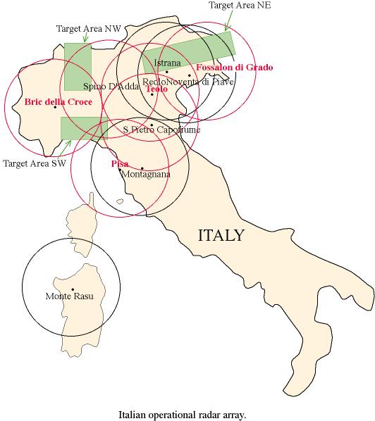
T.Col. Frustaci invited Dr. Marco Monai, of the Veneto Regional Meteorological Center, and Dr. Marco Gabella, Director of the Bric della Croce radar, to attend meetings in the afternoon. Dr. Monai was accompanied by Dr. Alberto Fontana from the Teolo radar. Dr. Monai provided extensive and precise information about all the operational weather radars in northern Italy. This information is summarized in Table 1. Dr. Gabella presented a summary of the status of the Bric della Croce radar, which is under construction and which is important to MAP because it covers the Piemonte region, one of the three major zones of heavy precipitation and flooding along the Mediterranean slopes of the Alps.
 A very fruitful
discussion ensued about the need for Italian operational radar data at
the POC. The U.S. delegation explained the plans for using
MountainZebra as the focal point of operations. Three-dimensional
radar data from radars along the southern slopes of the Alps and the
plains upwind will be ingested into MountainZebra to form a high
resolution 3-D composite radar map which can be used to guide the
aircraft horizontally and vertically through the regions of the most
scientifically interesting precipitation. Three-dimensional data from
4 Italian operational Doppler weather radars will be combined in
MountainZebra with 3-D data from the RONSARD, Monte Lema, and S-Pol
radars, and with the real-time flight-track data, to form the
composite product used by the ground-based scientists. The Italian
operational radars of interest for full
volume data are Bric della Croce, Teolo, Fossalon, and Pisa.
A very fruitful
discussion ensued about the need for Italian operational radar data at
the POC. The U.S. delegation explained the plans for using
MountainZebra as the focal point of operations. Three-dimensional
radar data from radars along the southern slopes of the Alps and the
plains upwind will be ingested into MountainZebra to form a high
resolution 3-D composite radar map which can be used to guide the
aircraft horizontally and vertically through the regions of the most
scientifically interesting precipitation. Three-dimensional data from
4 Italian operational Doppler weather radars will be combined in
MountainZebra with 3-D data from the RONSARD, Monte Lema, and S-Pol
radars, and with the real-time flight-track data, to form the
composite product used by the ground-based scientists. The Italian
operational radars of interest for full
volume data are Bric della Croce, Teolo, Fossalon, and Pisa.
Dr. Monai had not previously been aware of this need, and he helped us conceive a stepwise plan. The first step (highest priority) is to assure that first gif, and then numerical single-level horizontal maps of low-level reflectivity from northern Italian radars are available for ingestion into MountainZebra. The second step (more complicated) is to provide numerical, 3-D Cartesian data from 3-4 radars for ingestion into MountainZebra. The third and final step is to provide numerical, 3-D polar data from 3-4 radars for ingestion into MountainZebra. At present, the formats for these radar products have not all been determined.
ACTION ITEM-To facilitate this plan, Monai will make samples of the data available to Brodzik at each step, so that she can develop routines to convert the formats to those suitable for interpolation to a three-dimensional Cartesian grid and ingestion into MountainZebra.
ACTION ITEM-Brodzik will contact both Alberto Fontana (Teolo) and Marco Gabella (Bric della Croce) to obtain sample radar data and format information and will develop routines to enable ingestion of radar data into MountainZebra.
A composite, single-level horizontal map derived from Fossalon di Grado, Noventa di Piave, Istrana, and Teolo data is currently being developed and will be available in April 1999. This product is also potentially very useful to the POC operations.
ACTION ITEM-When the composite product becomes available, Brodzik will obtain a sample so that she can develop an appropriate MountainZebra ingest routine.
A major problem in providing the information needed for the MountainZebra composite is the transmission of the 3-D radar data. We asked for the help and advice of T. Col. Frustaci in obtaining information on the availability and cost of ISDN/CDN lines from the S-Pol and RONSARD radars. Alternate internet avenues are also being considered. The data from the Italian operational radars will flow through existing lines in the military network (Bric della Croce) or through ISDN lines from the radars via CNMCA (National Center for Meteorology and Climatology) in Rome to the POC. All lines required to transmit the Italian operational data to the POC are currently in place except for the one from Spino D'Adda to the POC.
ACTION ITEM-Brodzik will test the transmission of the radar products from the Italian operational radars to the POC during her testing at the POC in spring 1999. There may be some bandwidth problems or timeline issues that need to be addressed.
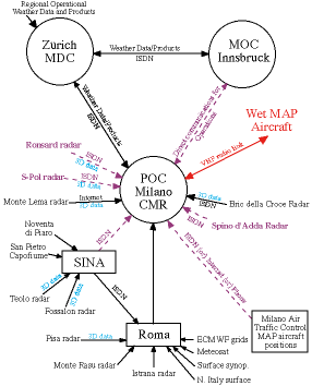 The U. S. delegation together with T.Col. Frustaci
prepared a comprehensive schematic diagram of the communications needs
for the POC during MAP. It is complex and multi-faceted as shown in
Fig. 2 on the right (click for caption). The Italians will help a
great deal but there are some critical gaps that need to be
filled. Most critically, The costs of ISDN lines to transmit RONSARD
and S-Pol data to the POC will not be covered by Italy.
The U. S. delegation together with T.Col. Frustaci
prepared a comprehensive schematic diagram of the communications needs
for the POC during MAP. It is complex and multi-faceted as shown in
Fig. 2 on the right (click for caption). The Italians will help a
great deal but there are some critical gaps that need to be
filled. Most critically, The costs of ISDN lines to transmit RONSARD
and S-Pol data to the POC will not be covered by Italy.
ACTION ITEM-Communication links to S-Pol and RONSARD and the method of paying for them need to be established. A major question: Do we need ISDN links to both radars given their proximity? Can an internet link be used, for example via University Milan?
ACTION ITEM-Housing for scientists during the SOP was discussed. Hotels in the vicinity of the POC are very expensive. JOSS will now look into the housing options for the SOP for participants residing in the greater Milano area. We have several leads that are being followed. There appear to be apartments and other types of residences available but location and price are ill defined at this time.
The main new item considered was the schedule of daily communication between the POC and MOC forecasters and scientists. The strawman plan developed out of this discussion was presented and extensively discussed and further modified at the Ascona MAP Planning Workshop during the week of 26-30 October 1998. The plan calls for a regular schedule of communication between the POC and MOC each day. Included in these contacts must be a conversation between POC and MOC forecasters, other conversations between lead PIs at POC and MOC, and a voice or video connection for a daily joint MOC/POC meeting. The communication between PIs should include discussions between lead Dry and Wet MAP PIs early in the day to head off potential conflicts in plans for facilities on any given day. The final outcome of these discussions will be documented in the MAP Operations Plan.
This trip focused on issues specific to operations at the POC. Wet MAP is getting excellent help from CMR in Milano, the SMA in Zürich, the Ticino Observatory in Locarno, and the Italian operational radar groups. The survey team now better understands the complexity of support required at the POC to support primary Wet and occasional Dry MAP operations. The real time requirements for delivery and display of operational and research radar data will require a major effort in the next 11 months. The many action items listed throughout the document above suggest that a high level of collaboration among international agencies, scientists, and technical and operations support staff will be necessary to have the POC ready for the SOP.
These action items will be monitored by JOSS and/or the University of Washington. Progress toward completion of these actions will be posted on this web site. There are several crucial resource decisions that will determine the success of MAP support at the POC. These include the provision of adequate communication lines with ATC, MOC, and project radars as well as the technical support necessary to implement the real-time tools (MountainZebra, ATC dedicated radio link, MAP aircraft flight tracks from ATC) to assure high quality and safe aircraft coordination during flight operations.
Bob Houze, Professor of Atmospheric Sciences, University of
Washington.
Stacy Brodzik, Software Engineer and Data Manager,
Mesoscale Group, University of Washington.
Jim Moore, UCAR, Joint
Office of Science Support.
Dick Dirks, UCAR, Joint Office of
Science Support. Dick participated only in the Milano meetings.